Geography of Malaysia
| Geography of Malaysia | |
|---|---|
 |
|
| Continent | Asia |
| Region | Southeast Asia |
| Coordinates | 2°30'N 112°30'E |
| Area | Ranked 66th 329,847 km2 (127,354.6 sq mi) 99.63% land 0.37% water |
| Borders | Total land borders 3,147.3 km (1,956 mi) Thailand: 646.5 km (402 mi) Indonesia: 2,019.5 km (1,255 mi) Brunei: 481.3 km (299 mi) |
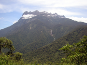
| Highest point | Mount Kinabalu (4,095 m) |
| Lowest point | Indian Ocean (0 m) |
| Longest river | Rajang River |
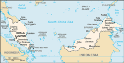
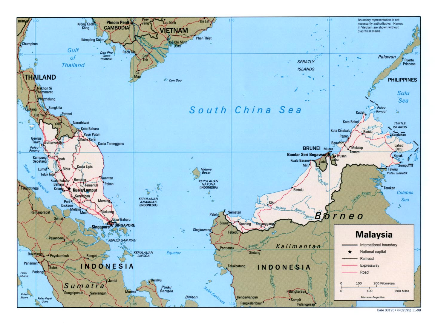
The geography of Malaysia deals with the physical and human geography of Malaysia, a country located in Southeast Asia. There are two distinct parts to this country being Peninsular Malaysia to the west and East Malaysia to the east. Peninsular Malaysia is located south of Thailand, north of Singapore and east of the Indonesian island of Sumatra. East Malaysia is located on the island of Borneo and shares borders with Brunei and Indonesia.
Contents |
Climate
Located near the equator, Malaysia's climate is categorised as equatorial, being hot and humid throughout the year. Annual rainfall exceeds 2000mm a year and the average temperature is 27 °C (80.6 °F).[1] Malaysia faces two monsoon winds seasons – the Southwest Monsoon from late May to September, and the Northeast Monsoon from November to March. The Northeast Monsoon brings in more rainfall compared to the Southwest Monsoon.[2]
The highest temperature was recorded at Chuping, Perlis on 9 April 1998 at 40.1 °C (104.2 °F). The lowest temperature was recorded at Cameron Highlands on 1 February 1978 at 7.8 °C (46.0 °F). The highest rainfall recorded in a day was 608 mm (23.9 in) in Kota Bharu, Kelantan on 6 January 1967. The highest rainfall recorded in a year was 5,687 mm (223.9 in) at Sandakan, Sabah in 2006. Meanwhile, the lowest rainfall recorded in a year was 1,151 mm (45.3 in) at Tawau, Sabah in 1997.[3]
The wettest place in Malaysia is Kuching, Sarawak with an average rainfall of 4,128 mm (162.5 in) with 247 days of rain a year. The driest place in Malaysia is in Chuping, Perlis with average rainfall of only 1,746 mm (68.7 in) a year.[3]
Land
The total land area of Malaysia is 329,847 km², the 66th largest country in the world in terms of area. Peninsular Malaysia makes up 131,000 km² or 39.7%, while East Malaysia covers 198,847 km² or 60.3% of the total land of the country. About half of Peninsular Malaysia is covered by granite and other igneous rocks, a third more is covered by stratified rocks older than the granite, and the remainder is covered by alluvium.[4] The terrain can be characterised as coastal plains which rises towards the hills and mountains.
From the total land area, 1,200 km² or 0.37% is made up of water such as lakes, rivers, or other internal waters. Malaysia has a total coastline of 4,675 km, whereby Peninsular Malaysia has 2,068 km, while East Malaysia has 2,607 km of coastline. Malaysia has the 29th longest coastline in the world.
Mountain ranges
The highest mountain range in Malaysia is the Crocker Range in Sabah. This range houses Mount Kinabalu, the highest mountain in the country, as well as Mount Tambuyukon, the third highest in the country. The Trus Madi Range, also in Sabah, houses Mount Trus Madi, the second highest peak in Malaysia. Bombalai Hill in Sabah is the only active volcano in Malaysia.
The main mountain range in Peninsular Malaysia is the Titiwangsa Mountains. It houses Mount Korbu, the second highest peak in the Peninsular. The highest peak in the Peninsular is Mount Tahan, located on the Tahan Range.
Forests
Malaysian forests can be categorised as tropical rainforest. This can be further divided into dipterocarp, swamps, and mangrove forest. Approximately 58.2% of Malaysian land is covered by forest.[5] Some areas are designated as forest reserves, state parks, or national parks. The management of these reserves as under control of the Department of Wildlife and National Park, the Forest Department of Sarawak, the Sabah Forestry Department, Sabah Foundation, and Sabah Parks. As of 2000, there are two World Heritage Sites under the natural category – Kinabalu National Park and Gunung Mulu National Park.
Islands
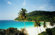
There are numerous islands found everywhere in Malaysia. The largest island is Banggi Island in Sabah, followed by Betruit Island in Sarawak, Langkawi in Kedah, and Penang Island in Penang. The largest island shared with another country is Borneo, followed by Sebatik Island. In addition, Malaysia lies within the world's coral reef distribution.[6] The reefs can be usually found around islands such as Sipadan Island, Swallow Reef, and Redang Island.
Extreme points
The southernmost point of Malaysia is located in the district of Serian in Sarawak. Tanjung Piai on the southern tip of Johor is the southermost point in Peninsular. The easternmost point is found on the tip of Dent Peninsular in Lahad Datu district in Sabah. The northernmost point is found on the northern tip of Banggi Island. The westernmost point is found on the western tip of Pulau Langkawi in Kedah.
Bodies of water
Between Peninsular Malaysia and East Malaysia is the South China Sea, the largest body of water around Malaysia. Facing the western coast of Peninsular Malaysia there is the Straits of Malacca towards the south, and the Andaman Sea towards the north. These seas are marginal seas of the Indian Ocean. Off the east coast of Peninsular Malaysia is mainly the South China Sea, while a small part in the north lies within the Gulf of Thailand. These form part of the marginal seas of the Pacific Ocean. The Straits of Johor off the south of Peninsular acts as a maritime border of Malaysia and Singapore.
In East Malaysia, the western coasts of Sabah and Sarawak faces the South China. The northeast coast of Sabah faces the Sulu Sea, while the southeast coast of Sabah faces the Celebes Sea. Between southern Borneo and southern Peninsular and the island of Sumatra is the Karimata Strait.
Malaysia claims 12 nm (22 km) as its territorial waters. It also claims 200 nm (370 km) of exclusive economic zone. In addition, Malaysia claims 200 m in the depth of the continental shelf or to the depth of exploration in within the area below the South China Sea known as Sundaland.[7] The territorial claim for the Straits of Malacca is shared between Malaysia and Indonesia in accordance to a treaty signed in 1970 known as the Treaty Between the Republic of Indonesia and Malaysia on Determination of boundary Lines of Territorial Waters of the two Nations at the Strait of Malacca.[8]
Lakes
The Bera Lake in Pahang is one of the largest lakes in Malaysia, and one of the only two natural lakes in Malaysia with Tasik Chini. Pedu Lake is a 12 km-long lake located 5 km from the Malaysian-Thai border and Kenyir Lake is the largest artificial lake in Southeast Asia.
Rivers
There are many systems of rivers found around Malaysia. The longest is the Rajang River in Sarawak with a length of 760 km. The second longest is the Kinabatangan river in Sabah with a length of 560 km. The longest river in the Peninsular Malaysia is Pahang River with a length of 435 km.
Natural disasters
Flooding

With 189 water basins in Malaysia and an average rainfall of over 2000mm per year, Malaysia is prone to flooding. There has been 15 major flooding in Malaysia since 1926. Flooding has been a larger concern today due to rapid development in the river catchment area which increase the river runoff and decreasing the river capacity. The recent 2006 and 2007 flooding in Johor has resulted in loss of RM1.5 billion and 18 lives in addition displacing 110,000 people temporarily.[9]
Seismic activity
Malaysia is situated between two major boundaries of tectonic plates, Australian Plate and Eurasian Plate in the west of Peninsular Malaysia and Philippine Sea Plate and Eurasian Plate in the East of Malaysia. Tremors, mostly non-lethal can be felt in Malaysia, caused by earthquakes in Sumatra islands of Indonesia and the Philippines.[10]
Impacts of seismic activity on building in Malaysia has heighten interest since the 2004 Indian Ocean earthquake. Although Malaysia is seismically stable, areas of concern are the west coast of Peninsular Malaysia such as Penang and Kedah and also the eastern state of Sabah.[11]
Natural resources
Minerals and petroleum
Malaysia produces petroleum and is a net exporter.[12] Malaysia also produces liquefied natural gas as well as various other related products, most of which are found off the coasts of Terengganu, Sabah, and Sarawak. Natural resources:tin, petroleum, timber, copper, iron, ore, natural gas, bauxite
Malaysia was the largest exporter of tin until the industry wide collapse in 1980s. Tin deposit are found in Selangor, Kinta valley in Perak, Pahang and Johor.[13] There are significant deposit of gold in Pahang towns of Raub and Kuala Lipis and also Kelantan's district of Gua Musang.[14]
Coal is mostly concerated in Sarawak town of Kapit, Mukah and Silantek.
Forestry
Timber can be found in the vast jungles in Malaysia, especially in East Malaysia. Malaysia total exports for timber and other timber products amounted to MYR 23.4 billion in 2007.[15]
Land use
Large areas of land are used as palm oil plantations, rubber plantations, and paddy fields. Malaysia is the largest exporter of palm oil in the world producing 15.8 million tonnes of crude palm oil in 2007.[12][15] Malaysia is also one of the largest producers and exporters of rubber and other rubber products.[16]
In 2001 the percentage arable land in Malaysia is 5.5%. Croplands consists of 17.6%, and pasture 0.9%. Forests covers 58% while other land uses consists of 17%.[17] In 1998, irrigated land covers 2,941 km².
Human geography
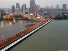
Peninsular Malaysia is more populated than East Malaysia where 79.2% of the population lives in the Peninsular. In 2002, 59% of Malaysian population lived in urban areas, while the rest live in rural areas.[18] The largest city is Kuala Lumpur with a population of 1.89 million people in the city, and about 7 million in the metropolitan area known as Klang Valley. Other major cities include Georgetown, Johor Bahru, Ipoh, Kuching, and Kota Kinabalu.
Political geography
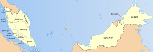
Malaysia is divided into thirteen states and three Federal Territories. Eleven states and two Federal Territories are found in Peninsular Malaysia. While two states and one Federal Territory are found in East Malaysia. The states are further divided into administrative districts. In Sabah and Sarawak, they are first divided into divisions, then further divided into districts. There are separate subdivisions for electoral districts for polling purposes.
International borders between Malaysia and Indonesia, Thailand, Singapore and Brunei are defined mostly by geological features such as the Perlis River and Golok River between Malaysia and Thailand; Straits of Johor between Malaysia and Singapore; and Pagalayan Canal between Malaysia and Brunei. However, borders that extends to the seas are defined by agreements such as Straits Settlement and Johore Territorial Waters Agreement of 1927 which defines Malaysia and Singapore water borders.
Malaysia's land borders are well established. The border with Thailand was established in 1909 when Siam ceded Kedah, Kelantan, Perlis and Terengganu to the British. Maritime border disputes between Brunei and Malaysia and a Bruneian claim on Limbang, Sarawak were resolved in an exchange of letters between the two countries on 16 March 2009 after 20 years of negotiations.[19] Malaysia and Indonesia have some overlapping maritime claims, notably in the area around Sabah. An ongoing series of meetings to resolve these claims has produced 16 border agreements (to September 2010).[20][21] Malaysia and Singapore also have disputes concerning some maritime borders.[22] The Philippines has a dormant claim to the Malaysian state of Sabah.[22] Malaysia is also involved in a complex dispute, involving Vietnam, Brunei, China, the Philippines and Taiwan, concerning the Spratly Islands in the South China Sea[22].
See also
- Environment of Malaysia
References
- ↑ "Malays Travel Guide:Climate of Malaysia". Circle of Asia. http://www.circleofasia.com/Geography-and-Climate-Malaysia.htm. Retrieved 2008-07-28.
- ↑ "Weather phenomena". Malaysian Meteorological Department. http://www.kjc.gov.my/english/education/weather/monsoon01.html. Retrieved 2008-07-31.
- ↑ 3.0 3.1 "General Climate Information". Malaysia Meteorological Department. http://www.met.gov.my/english/education/climate/info.html. Retrieved 2008-07-28.
- ↑ Encyclopædia Britannica. The Land (West Malaysia).
- ↑ Tropical Forest Mapping and Monitoring in Malaysia, Global Observation of Forest Cover Workshop, 1999-03-15, pp. 1–2, http://www.eoc.ukm.my/forest.pdf, retrieved 2008-07-30
- ↑ "Coral reef image". NASA. http://www.nasa.gov/vision/earth/lookingatearth/coralreef_image.html. Retrieved 2008-07-31.
- ↑ "Maritime Claims". CIA The World Factbook. https://www.cia.gov/library/publications/the-world-factbook/fields/2106.html. Retrieved 2008-07-31.
- ↑ "Indonesia-Malaysia Territorial Sea Boundary". The Geographer, Department of State, USA. http://www.state.gov/documents/organization/61516.pdf. Retrieved 2008-07-31.
- ↑ "Flood and Drought Management in Malaysia". Ministry of Natural Resources and Environment Malaysia. 2007-06-21. http://www.met.gov.my/ClimateChange2007/session1b/Keynote%20Lecture%202%20-%20Ir.%20Haji%20Ahmad%20Husaini%20Sulaiman/K2%20Husaini_p.doc. Retrieved 2008-08-01.
- ↑ "Keseismikan Malaysia" (in Malay). Meteorological Department of Malaysia. http://www.met.gov.my/malay/pendidikan/seismologi/seismo01.html. Retrieved 2008-07-30.
- ↑ Dr Salleh Buang (2006-04-26). "Dealing with a restless planet". New Straits Times. http://www.nst.com.my/Weekly/PropertyTimes/News/Land%20Matters/20050714124802/Article/. Retrieved 2008-07-31.
- ↑ 12.0 12.1 "Malaysia export growth slows to 16.9%". International Herald Tribune. January 4, 2005. http://www.iht.com/articles/2005/01/03/bloomberg/sxringgit.php. Retrieved 2008-07-30.
- ↑ "Tin Mine Operators in Malaysia". Geoscience and Minerals Department of Malaysia. http://www.jmg.gov.my/files/MALAYSIA&ASEAN/Tin.htm. Retrieved 2008-08-04.
- ↑ "Gold Mine Operator in Malaysia". Minerals and Geoscience Department of Malaysia.
- ↑ 15.0 15.1 "Key Statistics of Malaysia". Department of Statistics Malaysia. http://www.statistics.gov.my/english/frameset_keystats.php. Retrieved 2008-07-30.
- ↑ "Malaysia Chemical Reports 2008". Business Monitor International. http://www.businessmonitor.com/chemicals/malaysia.html. Retrieved 2008-07-31.
- ↑ "Environment at a Glance 2004: Malaysia". World Bank. http://siteresources.worldbank.org/INTEEI/Data/20857122/Malaysia.pdf. Retrieved 2008-07-31.
- ↑ "FACT Sheet Malaysia: Rural Women in the Malaysian Economy". Food and Agriculture Organization for the United Nations. http://www.fao.org/docrep/008/ae549e/ae549e01.htm. Retrieved 2008-07-30.
- ↑ "Border Issues Between Malaysia, Brunei Solved: Official". CRIENGLISH.com. Xinhua. http://english.cri.cn/6966/2010/05/03/1361s567255.htm. Retrieved 2010-09-06.
- ↑ "Indonesia, Malaysia to discuss border issues in September". English news, xinhuanet.com. Xinhua. http://news.xinhuanet.com/english2010/world/2010-08/25/c_13462015.htm. Retrieved 2010-09-06.
- ↑ "Malaysia, Indonesia ministers meet to soothe tensions". Asia Pacific News, channelnewsasia.com. MediaCorp. http://www.channelnewsasia.com/stories/afp_asiapacific/view/1079478/1/.html. Retrieved 2010-09-06.
- ↑ 22.0 22.1 22.2 CIA. The World Fact Book: Malaysia. Retrieved 9 December 2006.
External links
|
|||||||||||||||||||||||||||||||||||||||||||||||||||||||||||||||||